
File:Rio San Pablo.jpg

Size of this preview: 457 × 599 pixels. Other resolutions: 183 × 240 pixels | 366 × 480 pixels | 586 × 768 pixels | 781 × 1,024 pixels | 1,562 × 2,048 pixels | 3,451 × 4,525 pixels.
Original file (3,451 × 4,525 pixels, file size: 7.69 MB, MIME type: image/jpeg)
| This is a file from the Wikimedia Commons. Information from its description page there is shown below. Commons is a freely licensed media file repository. You can help. |
Summary
| Description |
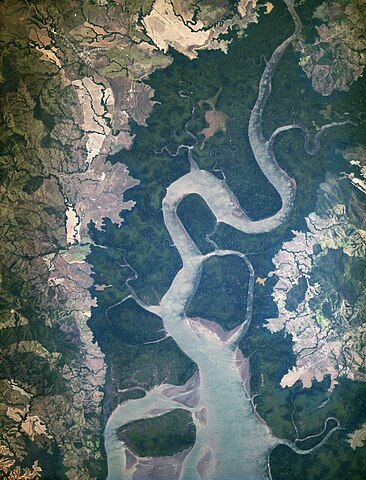
English: The image above is the “first light” from the new ISERV camera system, taken at 1:44 p.m. local time on February 16, 2013. It shows the Rio San Pablo as it empties into the Golfo de Montijo in Veraguas, Panama. It is an ecological transition zone, changing from agriculture and pastures to mangrove forests, swamps, and estuary systems. The area has been designated a protected area by the National Environmental Authority (ANAM) of Panama and is listed as a “wetland of international importance” under the Ramsar Convention. (Note that the image is rotated so that north is to the upper right.) |
| Date | |
| Source | https://flic.kr/p/e1EQPs |
| Author | NASA |
Licensing
| This image was originally posted to Flickr by NASA Goddard Photo and Video at https://www.flickr.com/photos/24662369@N07/8540216464. It was reviewed on 4 August 2014 by FlickreviewR and was confirmed to be licensed under the terms of the cc-by-2.0. |
This file is licensed under the Creative Commons Attribution 2.0 Generic license.
- You are free:
- to share – to copy, distribute and transmit the work
- to remix – to adapt the work
- Under the following conditions:
- attribution – You must give appropriate credit, provide a link to the license, and indicate if changes were made. You may do so in any reasonable manner, but not in any way that suggests the licensor endorses you or your use.
| This file is in the public domain in the United States because it was solely created by NASA. NASA copyright policy states that "NASA material is not protected by copyright unless noted". (See Template:PD-USGov, NASA copyright policy page or JPL Image Use Policy.) | ||
 |
Warnings:
|
File history
Click on a date/time to view the file as it appeared at that time.
| Date/Time | Thumbnail | Dimensions | User | Comment | |
|---|---|---|---|---|---|
| current | 19:09, 4 August 2014 | | 3,451 × 4,525 (7.69 MB) | Numéro 1963 | User created page with UploadWizard |
File usage
The following pages on the English Wikipedia use this file (pages on other projects are not listed):
Global file usage
The following other wikis use this file:
- Usage on ceb.wikipedia.org
- Usage on es.wikipedia.org
- Usage on www.wikidata.org
- Usage on zh.wikipedia.org